Beyond the Frontlines: The Long Tail of Pacific Theater Remnants
Conflict photography traditionally fixates on the kinetic energy of active frontlines. The alternative approach examines the decades-long aftermath of violence, focusing on the quiet, persistent scars left upon the land and its people. Selecting the Pacific theater over contemporary conflict zones involved analyzing the visual degradation of military steel over eight decades in high-humidity environments to emphasize long-term environmental integration. The most profound stories often begin after the treaties are signed and the international press corps departs.
The sudden departure of these global observers leaves a vacuum, shifting local attention from geopolitical events to daily survival. This transition accompanies broader economic realignments as communities move from wartime survival to reconstruction. A visual anthropologist reads the slow oxidation of military steel to comprehend environmental endurance.
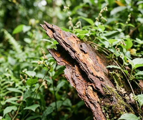
The landscape permanently absorbs abandoned military infrastructure — metallurgical surveys of tropical environments indicate as much. Iron oxidation rates in tropical environments with 82 to 88 percent average annual humidity dictate the pace of this decay. After 75 to 80 years of jungle reclamation, the distinction between natural topography and artificial fortification blurs entirely. Documenting this requires a shift in visual strategy, moving away from the dramatic action of combat toward the subtle, enduring presence of history.
Isolating Oxidized Steel Within Melanesian Flora
Aperture settings between f/2.8 and f/4.0 isolate foreground subjects. This optical isolation is necessary when documenting Marston Matting sections measuring 10 feet by 15 inches. Initially, the approach relied on wide-angle landscape shots to capture the scale of abandoned airfields. This was discarded because the rusted steel blended too seamlessly into the undergrowth. Instead, the decision shifted to using an 85mm macro lens to isolate the jagged edges of the steel against the soft focus of the surrounding flora.
Recognizing subtle environmental changes requires a trained eye. Bomb craters find new utility as agricultural ponds. Airstrip matting serves as property boundaries. The visual contrast between the natural beauty of Melanesian landscapes and the harsh, rusting geometry of unexploded ordnance creates narrative tension. Depth of field and natural lighting emphasize the integration of military remnants into civilian life while keeping these historical artifacts distinct.
Distinguishing Historical Steel from Modern Fencing
Failure to differentiate between oxidized Marston Matting and standard agricultural fencing in Melanesian topsoil compromises the historical integrity of the visual record. Photographers must verify the origin of the materials before framing the shot.
The 85mm lens compresses the background, bringing the dense jungle canopy closer to the rusted subject. This compression highlights the ongoing battle between industrial decay and organic growth. The rust itself becomes a subject, its textured, flaking surface contrasting sharply with the smooth, vibrant leaves of the encroaching vines. Capturing this texture requires precise focus and an understanding of how tropical light filters through the canopy.
Establishing Secure Perimeters Around Unexploded Ordnance
Documenting contaminated zones demands absolute adherence to established safe lanes. Establishing a shooting perimeter meant coordinating with local demining teams to map out a strict safe lane, ensuring tripod legs never breached uncleared topsoil. These safe lanes are restricted to 3 to 5 meters in width. The photographer's role remains strictly observational, documenting the clearance process without ever interfering with or handling the remnants.
The tripod footprint is kept within a 24-inch radius of verified cleared ground. Working alongside certified clearance personnel ensures that the documentation process does not endanger the crew or the community. However, these clearance protocols apply strictly to officially surveyed UXO zones and cannot guarantee safety in undocumented secondary jungle growth where seasonal flooding shifts buried ordnance.
The decision to photograph in these undocumented areas carries catastrophic risk — a single misstep yields catastrophic consequences. The margin for error is nonexistent. Every movement must be calculated, every step verified. The tension of working in these environments translates into the final images, imbuing them with a sense of underlying danger despite the outward tranquility of the landscape.
UXO Zone Photography Protocol
- Verify safe lane boundaries with local clearance personnel before unpacking gear.
- Equip tripod legs with wide-base feet to prevent accidental soil penetration.
- Map out a 24-inch maximum movement radius for the camera operator.
Earning Visual Consent Among Displaced Populations
Field observations showed that introducing a camera too early disrupted the natural rhythm of a resettled community. Determining the right moment to introduce the camera involved participating in daily agricultural routines without equipment, allowing the community to dictate the pace of the visual documentation. This ethical framework requires investing time to understand the community's current rebuilding efforts rather than solely focusing on their past trauma.
In this work, initial integration periods lasted 3 to 4 days before equipment was introduced. Subsequent interviews spanned 45 to 90 minutes to establish informed consent. Collaborating with subjects ensures their dignity is preserved in the final images. This approach supports ethical documentation in post-conflict zones.
Human connection takes priority over immediate image capture. When photographing displaced populations and trauma survivors, the camera must act as a tool for empowerment rather than extraction. By participating in the daily life of the community, the photographer gains a deeper understanding of the subtle ways in which the past continues to shape the present. This understanding informs the visual narrative, resulting in images that are both respectful and profoundly revealing.
Prioritizing Community Rhythm Over Capture Speed
Allowing the community to dictate the pace of documentation ensures that the resulting images reflect their resilience and agency, rather than imposing an external narrative of victimhood.
Metering the Canopy: A Solomon Islands Still Life
Deep within a Solomon Islands garden, the humid air hangs heavy over the broad, vibrant green leaves of a taro plant. Resting against the base of the stalk sits a heavily oxidized WWII artillery shell, its rusted iron casing flaking into the damp, dark soil. The farmer moves quietly in the background, tending to the roots, entirely accustomed to the lethal geometry sharing space with the evening meal.
Setting up the stabilized tripod requires deliberate, slow movements to avoid disturbing the delicate root system or breaching the verified safe zone. Metering the scene required spot-metering the highlights on the taro leaves and the deep shadows of the oxidized mortar casing, ultimately underexposing slightly to retain the rich greens of the canopy light. The exposure times range from 1/15 to 1/30 of a second, capturing the absolute stillness of the humid air.
Adjusting Exposure for Regional Canopy Density
This metering technique is calibrated for the dense canopy light of the Solomon Islands and will overexpose subjects in sparse, arid post-conflict zones.
The mechanical click of the shutter breaks the silence of the garden for a fraction of a second. The slow exposure allows the ambient light to burn the image of the rusted mortar and the living taro into the sensor, sealing the enduring intersection of war and daily survival into a single, quiet frame.